Download Agreement, Release, and Acknowledgement of Risk:
You (the person requesting this file download) fully understand mountain climbing ("Activity") involves risks and dangers of serious bodily injury, including permanent disability, paralysis, and death ("Risks") and you fully accept and assume all such risks and all responsibility for losses, costs, and damages you incur as a result of your participation in this Activity.
You acknowledge that information in the file you have chosen to download may not be accurate and may contain errors. You agree to assume all risks when using this information and agree to release and discharge 14ers.com, 14ers Inc. and the author(s) of such information (collectively, the "Released Parties").
You hereby discharge the Released Parties from all damages, actions, claims and liabilities of any nature, specifically including, but not limited to, damages, actions, claims and liabilities arising from or related to the negligence of the Released Parties. You further agree to indemnify, hold harmless and defend 14ers.com, 14ers Inc. and each of the other Released Parties from and against any loss, damage, liability and expense, including costs and attorney fees, incurred by 14ers.com, 14ers Inc. or any of the other Released Parties as a result of you using information provided on the 14ers.com or 14ers Inc. websites.
You have read this agreement, fully understand its terms and intend it to be a complete and unconditional release of all liability to the greatest extent allowed by law and agree that if any portion of this agreement is held to be invalid the balance, notwithstanding, shall continue in full force and effect.
By clicking "OK" you agree to these terms. If you DO NOT agree, click "Cancel"...
Over Labor Day weekend, I finally made my first pilgrimage up to Ruby Basin. Over the past few years, I've gazed longingly out at the Weminuche from surrounding peaks. Whether it was the Kendalls, Ice Lakes, Vestal Basin, my eyes were constantly drawn to the Needles. I was sorta aware of what each peak was, recognizing different angles and features, but I was always perplexed where one peak/basin ended and the other began. I'd checked out the Chicago Basin 14ers back in 2019, but this year I knew I couldn't put off getting back there for another year.
My buddies, Jack and Wes, reached out about packing in a quick trip, when I got back to SW Colorado. I invited my roommate, Luke, and we settled on checking out Ruby Basin, with all of us psyched to at least try and climb Pigeon. We weren't initially feeling very ambitious, as we were hiking in on Friday Afternoon from Purgatory, and hiking back out on Sunday morning, leaving only Saturday to explore.
We set off from Purg TH around 3:45 and made the slog into Ruby. We got rained on most of the way, and showed up at Ruby Lake around 11 pm. We were honestly pretty worn out from the dark, wet approach, and collectively agreed to sleep in the next morning, knowing we had a perfect forecast.
Game faces
Pigeon coming out of the Clouds for a bit!
Rad sign, really nailed the shapes.
We woke up, dried out our clothes, and enjoyed a casual morning in the sun. We set off from our camp around ~10 AM (serious alpine start) It became pretty apparent that Luke and Wes were feeling significantly more worked from the long approach, so we decided to split up into two groups. This would allow Jack and me to potentially link in some other peaks, and for them to enjoy the day at a more relaxed pace. We split off right before the steep slope to the Pigeon/Turret saddle, and went on our way!
First Eyes on Peak 15. What a Hunk!
Pigeon's wild East face. One of the larger alpine walls in the state, it doesn't seem to host the rock quality necessary for any classic routes, but similar to the East face of Monitor, there is absolutely climbing history as well as potential on these remote walls.
We arrived at Pigeon's saddle, dropped pack/running belt, and started circling Pigeon towards the standard route. The standard route requires a big drop after reaching a notch directly south of Pigeon. I was feeling a bit stubborn, and not wanting to add in tons of extra gain on the way down/back up, I insisted to Jack that we try and find a sneak around pigeon, which could potentially drop us right along the standard route. We spotted a short headwall, which looked like it could deposit us onto ledge systems on Pigeon's west face. I followed goat tracks after the short headwall and found cruiser terrain along the west side, leading us to a notch on Pigeon's West ridge. We dropped shortly down the Notch and made our way along the 3rd-4th slabs in sight of the typical standard route.
Short 4+ headwall, leading us to Pigeon's West side.
What our route typically looked like. Pigeon's standard route would be just off to the left.
Looking down our route up Pigeon
We summited Pigeon at 1pm, 3 hours into the day. It was pretty surreal to finally be on top of a peak we'd been obsessing over for years. It truly has to be one of the most incredible summits and views around. We soaked it up for a bit, and reversed our route back to the saddle. I was pretty giddy to find that sneak and skimp out on a ton of the legwork.
Pigeon Summit
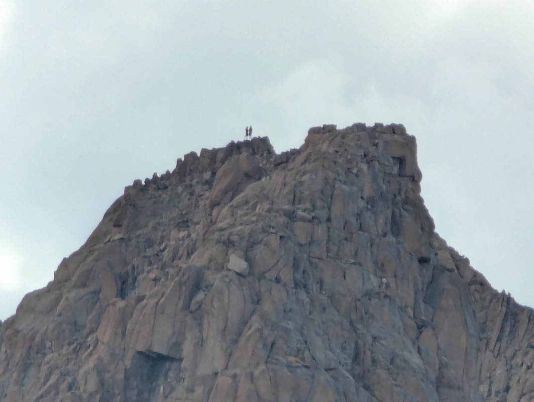
Summit block - bit reminiscent of Sunlight!
View of the day ! Engineer and Lone Cone lining up perfectly. We geeked out at this for a few minutes.
We arrived back at the saddle, hung out for a bit with our buddies, and decided to carry on to Turret. We were trying not to be unrealistic, but both of us were definitely keen on trying to link Pk 15 into it. We had one screenshot that showed there was a potential way to downclimb Turret's east side (?), but we both knew we would have to get eyes on it before we got too excited.
Heading Over to Turret - View back at Pigeon/Saddle
Beautiful rock on Turret
Summit of Turret! Looking over to Eolus - N Eolus. Peak 15 just left of center
Linking Turret and 15 was the crux of the day. Specifically, downclimbing Turret's East side, which was straightforward enough, yet highly exposed. The standard, yet still obscure way to link these peaks, is to drop down and around Turret's South side, from the saddle with Pigeon, and essentially go all the way into New York Basin. This allows you to avoid all the complex terrain and circumnavigate all the way to the standard route on Peak 15. Although it seems most people treat 15 as its own objective, understandably so. We scoped a good-looking line coming directly from the saddle with Turret, and figured if we could find our way to the saddle, we could give that line a try.
We took our time heading down Turret, exercising heightened caution with the infamous kitty litter, and found ourselves at the Turret/15 Saddle around 4.
Our line down Turret - Specific crux highlighted in red - Awkward transfer into another corner system, with pretty big exposure.
The line we scoped turned out to be surprisingly pleasant, consisting of mostly 4th - low 5th - with a 20-foot ~5.7 chimney crux. This deposited us on the S crest of Peak 15, which we followed up to the summit. Arriving at the top at 4:30, we chose not to linger for long, and turned right back around... soooo excited to go back up Turret.
Peak 15 - with and without our beta line. The chimney crux can be seen as a small dark shadow, right near the crest. We found a very old nut and carabiner, signifying someone had at least rappelled down this terrain before.
Peak 15 selfie!
Summit of 15 ! Looking back at Turret and Pigeon
Scambling up 15 - The line we descended on Turret, is bordering the right edge of the photo.
Scrambling down the S crest of 15 - Keeping an eye out for our chimney.
Animas - 13 - Monitor ... hmmmmm
Climbers across the basin, on top of Pk 13. Turned out they were friends! - @alexhenes!
Crux of our route on Pk 15 - Short and unexposed ~ 5.7 downclimb. The bail gear/rappel anchor was found in the crack on the left.
Wacky scrambling back over Turret - It's a bit difficult to comprehend the exposure, the kitty litter factor definitely amps it up.
By 5:30, we were back at the saddle of Pigeon/Turret. At this point, the fire was burning, and we were psyched! Our eyes shifted to the Monitor group, and we both felt like it was quite feasible to add them in. We started scheming and made quick work of the descent down into Ruby basin proper. We did a full pit stop at the creek, throwing down all the food and water we could, and started up Monitor at 6:30
Heading to Monitor
Sun is getting low, taken from the obvious ledge running underneath peak 13.
We had good beta for these three peaks, as Laura Clark wrote up a very useful report on Animas and Monitor. We utilized the same ledge under Peak 13, to access Monitor, and dropped our packs at the saddle between 13 and Monitor. By 7:30, we were watching the Needles absolutely light up on the summit. It was one of the better sunsets in my life!
We tried to take it in, but were conflicted by wanting to utilize the last bits of light, so we reluctantly headed back to the saddle. We didn't have much beta on 13 or how it connected to Animas, but it seemed straightforward, and we tried our best to analyze the terrain before things got dark.
Sunlight
Eolus + N
15 - Turret - and the La Plata's in the distance.
Beastly Jagged
Once we were back at our packs, we weaved around Peak 13, and summited via quality 3rd class on the ~ NE side of the peak. We enjoyed the very last bits of light, turning on our headlamps as we crested the summit. Dropping off 13 was a bit cruxy, and we encountered some 4th and low 5th, but this problem is likely avoidable with more info/sunlight. The section between Peak 13 and Animus went rather quickly, blocky class 3 with many options. The upper stretches did have a number of cairns, which we were able to follow. By 9, Jack and I were on the moonlit summit of Animas
Scoping out the drop, summit of Peak 13 - Animas in the center - Can spot the caribeaner and nut on my running belt... I think I accidentally dropped it on Animas's summit!
Descending Animas was a tad gritty in the dark, but once we stepped onto terra firma below the upper stretches, we knew the only way we could ruin our day would be wiping out from mentally checking out. So, we focused up and didn't rush the descent, reminiscing on the day and talking about the shmorgousborg we were going to assemble back at camp.
We arrived back at camp at 10:30, a little over 12 hours after setting out that morning. We feasted, watched shooting stars over Ruby Lake, and turned in for the night. The next morning, we made the knee-crushing trek down from Ruby Lake, and got back to Durango in the evening. The scenery, adventure, effort, company, and remoteness of the day culminated in one of the most memorable experiences I've had in the mountains. This zone is truly special!
Zen time
Last notes - I hope this report can provide some sort of usefulness, besides all the spray. I really wanted to highlight the terrain between Turret and Peak 15 for curious folks, especially because we essentially found nothing.
Peak 15 seems to have quite the reputation on this site, and I honestly think it's deserved. Although we did not take the standard route, all these peaks, especially 15, are complicated beasts. It's without a doubt one of the more difficult peaks in the state.
The kitty litter here is unforgiving, and it's ridiculously easy to lose your footing. Stay sharp!
I ran into a few friends up there and chatted with some strangers, who all felt like the approach took a significant toll and required them to scale back their expectations or objectives. It's good to keep in mind how deep you are back there!
Stats - Lotta Up - Lotta down
Thumbnails for uploaded photos (click to open slideshow):
I've been curious about the Turret>Pk 15 connection, your report makes it look pretty straightforward. Fwiw, I climbed Pk 15 years ago but via the standard route, another route might be worth the hike in. Thanks again,
Appreciate it Tom!
Seemed like the route we climbed could also be accessed from the gully between 15 and Turret, from New York basin, if you wanted to avoid that Turret descent
Yeah, funny you mention that, it's the reason for my post. NY Basin is the only basin I haven't spent much time in in that area (skirted it for my last Pk 15 climb). Sounds like it'd be a manageable adventure, a bit of bushwhacking which I perversely enjoy. Thanks again for your report.
Bubba’s is a great spot to eat. They are a staple of the local ranching and farming communities, and provide a family friendly American dining experience, all at a faur price. Not only were they bombed by Israel, but they also offer a “Hillbilly Six Pack,” consisting of 5 beers and - wait for it - a BOWL OF CHILI! Stop in at Bubba’s next time you're cruising hwy 491 on the western slope.
Dang, that is so cool! I think I'll add that pic to the report. Kudos on all of your big linkups. If you ever want to get out or rope up for anything, send me a message!
Awesome TR on an amazing day. Congrats and thanks for posting.
Caution: The information contained in this report may not be accurate and should not be the only resource used in preparation for your climb. Failure to have the necessary experience, physical conditioning, supplies or equipment can result in injury or death. 14ers.com and the author(s) of this report provide no warranties, either express or implied, that the information provided is accurate or reliable. By using the information provided, you agree to indemnify and hold harmless 14ers.com and the report author(s) with respect to any claims and demands against them, including any attorney fees and expenses. Please read the 14ers.com Safety and Disclaimer pages for more information.
Please respect private property: 14ers.com supports the rights of private landowners to determine how and by whom their land will be used. In Colorado, it is your responsibility to determine if land is private and to obtain the appropriate permission before entering the property.